How climate change is reshaping the Alps
BBC


By Vedrana Simičević, Mar. 23: It’s only 6 am but there are already more than a hundred people waiting for the cable car that leads from Chamonix to the top of Aiguille du Midi, in the French Alps. It is a scene that repeats here almost every day during the busy summer months.
Riding in the cabin that carries passengers to the top of the 3,842m (12,604ft) peak in only 20 minutes is one of the most popular attractions in the French mountaineering capital.
A rocket-shaped structure carved into the top of this majestic peak, complete with man-made tunnels and platforms, allows visitors to marvel at spectacular views of Mont Blanc. It also serves as one of the most unusual natural laboratories in the world.
“This place is unique because it gives us easy access to a very extreme environment,” says Matan Ben-Asher, a geomorphologist at the Laboratory of Environment Dynamics and Territories of the Mountain (Edytem) at the University Savoie Mont Blanc, in Chambery, France, while we make our way through the tunnels to the platform above the east face of Midi.
There, his colleague Josué Bock had already set three static ropes, throwing the other ends to a steep rock slope 30m (98ft) below the platform. Ignoring the numerous tourists curiously watching this procedure, the two researchers put on their helmets and climbing harnesses, and load a drill and laptop into a backpack before rappelling off into the void.
They will spend the next few hours hanging from the ropes about 200m (656ft) above the glacier, maintaining part of a sensor network installed through deep boreholes into the rock walls of Aiguille du Midi. One of their tasks is to repair a broken cable that connects the electrodes of a device for measuring electrical resistivity.
This expensive instrument is commonly used for the detection of water and minerals in the soil, but is not built to endure the freezing temperatures and frequent lightning strikes it experiences on the rockface beneath the cable car station.
Keeping it running is a vital task, however. Up here amidst the clouds, the scientists are deploying it for an innovative purpose – to monitor permafrost in the rock walls.
Most commonly associated with the polar regions, permafrost is soil and rocky material that stays frozen continuously for at least two years. Normally it lies beneath an “active layer” that melts and freezes depending on the season. Less well-known is that permafrost can also be found on steep mountain walls.
In the European Alps, more and more of it is thawing each year – and it is threatening the very mountains it is found in.

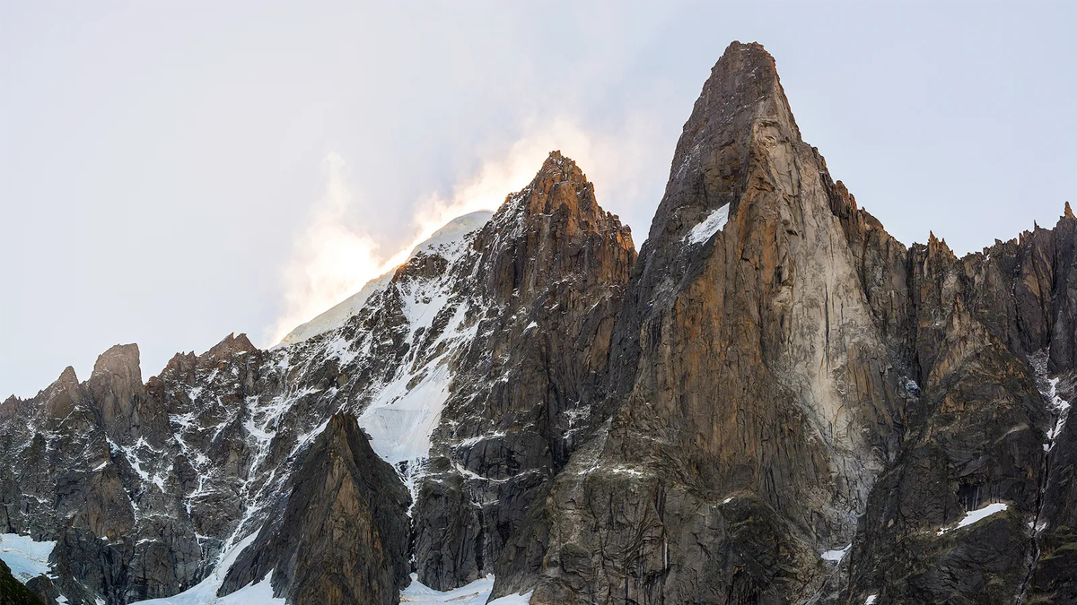
The imposing rock faces beneath the cable car station on Aiguille du Midi are a natural laboratory for monitoring the decay of permafrost in the Alps (Credit: Vedrana Simičević)
Permafrost in the Alps tends to be found above 2,500m (8,202ft) where it runs deep into cracks in the solid rock, helping to glue them together. Without it, the mountainsides can become unstable.
And the thawing is happening on two different timescales, explains Florence Magnin, another member of Edytem lab and one of the most prominent researchers studying how Alpine permafrost is affected by climate changes. Short-term thaws occur each summer, but heatwaves, which have been more frequent in this part of the French Alps since 2015, are taking their toll.
“If summer is warmer, the active layer, which means the layer above the permafrost that is always thawing in the summer, is becoming deeper every year,” she says. “This means that part of the layer now thaws for the first time ever, which can provoke destabilisation in the rock.”
The other timescale can be seen through the long-term data collected from the sensor network embedded in the rockface – it shows that every 10 years the average temperature deep inside the rock has increased by 1C (1.8F), due to the gradual deepening of the summer thaw. “This steady and slow warming can also provoke rockfalls”, says Magnin.
Older climbers from Chamonix still remember an anecdote about two Germans who in 1997 were climbing on the west face of Aiguille du Dru, a famous peak in the Mont Blanc massif.
At the end of the day, they settled to spend the night on the ledge in the upper part of the granite wall. Up to this point, their ascent had gone according to plan, but something was off – for hours they listened to frightening sounds coming from the depths of the mountain. Disturbed, they called the mountain rescue service in the morning.
Shortly after the helicopter lifted climbers from the wall, a massive rockfall, approximately 27,000 cubic metres (953,496 cubic ft) in volume, swept down the Dru west face.
Another massive rockfall in 2011 revealed the probable culprit – the remains of ice lurking beneath the fracture. It only confirmed what was already clear to scientists, that the main cause of unusually large rockfalls was the degradation of ancient permafrost that fills the cracks deep inside the walls.
“This kind of permafrost is usually not reachable, but rockfalls gave us the opportunity to date the ice. It was between 800 and 4,500 years old,” says Ludovic Ravanel, from Edytem Laboratory. Yet despite its age, it appears to be melting away.
We have clearly identified that permafrost degradation is one of the main causes of increased larger rockfalls – Jacques Mourey
As a geomorphologist and experienced mountain guide from a long line of mountaineers, Ravanel became motivated to focus on permafrost after the infamous European heat wave in 2003 triggered numerous rockfalls.
Two years later, he and his colleagues set up a monitoring network in the Mont Blanc massif using human observers and cameras, which has enabled them to collect data from more than 1,500 larger rockfalls so far.
In the last few years, the number of more significant events is rapidly increasing in many parts of the Alps, says Ravanel.
And there are fears that, in the coming decades, even larger rockfalls will drastically change the landscape of the mountains in the region.
With it, the danger for hikers and mountaineers grows as well. In 2017, large rockfalls from Pizo Cengalo, on the border of Italy and Switzerland, triggered an avalanche of rock and dirt that travelled down the valley, killing eight people.
Dangerous events continued to wreak havoc over last summer. And the route that was most seriously affected happened to be the most popular one – the easiest path to the top of Mont Blanc itself.
This line of ascent attracts an estimated 20,000 people each year, but on the way up they all have to cross the infamous “death couloir”. Extremely prone to falling rocks, this section of the so-called Goûter route up the mountain has been the scene of more than a hundred fatal incidents since the start of the 1990s.
Until recently, climbers would have to be somewhat unlucky to cross the 20m (66ft) wide couloir at the exact moment of a rockfall, but for the last few summers, flying rocks have been an almost constant occurrence, say climbing guides. In July 2022, numerous rocky avalanches forced mountain guides from Chamonix to stop taking clients on this route, effectively closing the mountain to less experienced mountaineers.
“We have clearly identified that permafrost degradation is one of the main causes of increased larger rockfalls,” says Jacques Mourey of the University of Lausanne, one of the scientists in charge of a small sensor network at the couloir. Their research showed that the ground temperature in the upper part of the couloir is increasing at a rate of 2C (3.6F) per decade.
To answer questions about what will happen in the future at high-risk places like Goûter couloir, the natural laboratory at Aiguille du Midi is important.
“There is probably no place like this in the world where you can just walk into the permafrost,” says Ben-Asher, talking about the tunnels that extend into the rockface. As a bonus, the pointy shape of the peak and connecting platforms enables researchers to move easily between differently-orientated rock faces.
The first temperature sensors were placed at Aiguille du Midi in 2005. Back then, the scientists spent days drilling three 10m-deep (33ft) boreholes in a hard and steep granite wall. Now, more than a decade of data from numerous types of sensors is providing a clearer view of how this deep permafrost is affected by rising temperatures as the climate warms.

The Goûter couloir has become particularly hazardous for mountaineers on Mont Blanc and some guides now refuse to use the route (Credit: Philippe Desmazes/AFP/Getty Images)
Their analysis suggests that the most destructive changes to the permafrost are usually happening six or more meters beneath the rock surface as summer heatwaves cause the temperature there to rise to between -2 and 0C (28-32F).
Thermal modelling of 209 rockfalls has shown that air temperatures at the surface were higher than usual up to two months and one to five days before a rockface failure.
There are a few ways in which the thawing of ice can cause the detachment of a large volume of rock. Most commonly, water accumulated in an existing fracture can build hydrostatic pressure strong enough to widen or break the crack. In other places, the permafrost may be the only thing keeping two rock layers glued together.
“We can see in the laboratory that if you attach two rock layers with the ice, detachment will already begin even at -3C [27F],” says Ravanel.
Scientists are now trying to learn more about the physical processes involved in rockface collapses.
“Water can be also efficient in taking the heat from the surface into the fractures, so we want to know how much water is going into rock and where it is coming from,” says Ben-Asher. Conveniently, in the dark tunnels of Midi high station, water seeps through cracks, making it easier to collect samples. To see what amount of the water is coming from the snow melt, scientists are using an old simple trick – dyeing the different snow packs with fluorescent colours.
“In this way, we have already identified three different sources, but in August [2022] the snow melted and the water was still coming from somewhere,” says Ben-Asher. On some days, the collecting buckets were fuller than usual without visible reasons.
This all could point to permafrost melting, so scientists are applying different methods to find out how much time the water they are collecting has spent in the rock. If it is very old, then it might indicate that ancient permafrost is now melting.
Meanwhile, 69km (39 miles) away, a separate group of scientists are collecting data from another remarkable permafrost field laboratory. The 4,478m-high (14,692ft) Matterhorn, located on the border of Italy and Switzerland, is widely regarded as one of the most beautiful mountains in the world. Motivated by rockfalls that occurred after the 2003 heatwave, Swiss scientists started setting up a wireless sensor network in 2006.
The task was more difficult than on Midi, mostly because there is no cable car that leads to the top of Matterhorn, only demanding climbing routes. Over the following 10 years, however, they managed to build a network comprised of 17 different sensor types, which have allowed them to gather more than 154 million data points.
Built around the worst of the rockfall locations, the network comprises temperature sensors, cameras, “crack meters” that measure the widening of the fractures, inclinometers, GPS sensors and seismic sensors that help them measure the formation and melting of ice in fractures deep within the rock.
All these field measurements and laboratory experiments are contributing to computer models to help predict the behaviour of the mountain permafrost in rising temperatures. Researchers hope it will allow them to identify the most dangerous locations in any mountain range at similar altitudes.

Scientists use a network of sensors to monitor the stability of the permafrost deep inside the Alpine rock face of Aiguille du Midi (Credit: Vedrana Simičević)
But it could take another 20 years, and a lot more data, until such models could be good enough to forecast large rockfalls, says Magnin.
Meanwhile, some of the findings are already directly helping to keep mountaineers safe. For example, it’s known that the most frequent rockfalls on the north faces of the Alps occur at a lower elevation and with higher frequency than on the south faces.
Even more specifically, thanks to the sensor network, scientists have identified the least dangerous time of the day for crossing the Goûter couloir in summer – from 9 am to 10 am, although climbers are still encouraged to check conditions before setting off.
The keenest to implement this knowledge are mountain guides, many of whom spend up to 200 days a year in the mountains, and see the effects of climate change first-hand. “At the beginning of July we now have conditions that we usually see in August,” says Olivier Greber, president of the Chamonix Guide Company.
In response, guides choose to climb some routes in colder conditions and avoid others completely. They are offering clients mountain adventures at lower altitudes and in less risky areas.
“We are also listening to advice from Ravanel and his colleagues,” adds Greber. “We learned to spot alarming signs – water pouring from the cracks, strange noises coming from the wall or evidence that a particular crack is becoming wider every year.”
Unaware of these threats, many mountaineers unfamiliar with the local context still chose to climb in dangerous conditions.
But the problem is much wider. In French Alps, says Ravanel, there are 947 elements of infrastructure located in the permafrost regions, from mountain huts to ski resort cable cars. Some of them were already affected by thawing. He believes that ensuring the safety of the Alps and the many people who visit them will only be a growing challenge.
“A decade ago I was not fully aware of the huge changes we would see,” says Ravanel. “So now I probably can’t imagine the rate of the processes we could confront in the next decade.”
BBC
- Country Experiencing Partial Influence of Westerly and Local Winds
- China’s Foreign Investment Inflows Dip 26.1% Despite ‘Openness’ Pledges
- Vice Admiral Dinesh Kumar Tripathi Appointed Next Chief of the Naval Staff
- India Lays Foundation Stone for High Impact Community Development Projects in Darchula, Nepal


Comments