China’s Deceptive Trend: Illegal Structures on Nepali Border Block Bhote Koshi River, Endangering Settlements


China’s recent release of a contentious map has stirred controversy in the international arena. This map, referred to as China’s ‘popular map,’ has garnered attention due to its assertive claims over vast territories. Notably, China has incorporated more than 90,000 square kilometers of land in Arunachal Pradesh and an additional 30,000 square kilometers of disputed territory in Aksai China, intensifying the ongoing disputes. What has added fuel to the fire is China’s inclusion of the South China Sea and Taiwan as integral components of its nation.
The prominent English daily ‘The Global Times,’ often recognized as the mouthpiece of China’s ruling Communist Party, reported, “China unveiled its much-discussed map for the year 2023 on Monday. This map is now accessible on the Ministry of Natural Resources’ official website. Constructed using China’s cartographic methodology, it also integrates mapping techniques employed by other global nations. An important point of contention is that, upon its release, Nepal refuted the existence of the Chuchche map, which delineated Lipulek, Kalapani, and Limpiyadhura, three years prior.”
As of now, Nepal has not officially conveyed any formal diplomatic or political response to this situation.
Why Does China Persist in Encroachment?
The persistence of China’s encroachment raises questions about its motivations and intentions. According to border expert Buddhinarayan Shrestha, there is a lack of comprehensive information from any agency regarding the severity of Nepal’s northern border’s geographic condition in relation to encroachments. Comparatively, the issue of land encroachment by China seems relatively minor. However, China’s recent denial of the existence of Nepal’s new map highlights a concerning trend. expert Shrestha suggests, “This exposes a diplomatic vulnerability on our part. China’s denial stems from Nepal’s failure to officially provide them with the English version of the new map. Despite this, China was already aware of Nepal’s geography.”
The 1961 demarcation indicates that the border with China is predominantly separated by imposing mountains and glaciers. Nepal, naturally divided from east to west, boasts 43 border crossings and checkpoints with China. This complex geographical disposition, combined with encroachments on the southern side, has somewhat overshadowed debates concerning the border dispute on the northern side.
In the previous year, China reportedly crossed the border at multiple points. However, the credibility of these reports and the sources cited therein came under scrutiny.
In the aftermath of the coalition government’s establishment, led by Prime Minister Sher Bahadur Deuba, a study task force was instituted to address the northern border dispute. Despite the resolution of this dispute during the 1960s through intensive negotiations at both high political and administrative levels, along with meticulous field studies, the issue has persisted and worsened due to a lack of consistent monitoring and pillar management. During this time, reports of disappearing border pillars and shifts in the former border became frequent occurrences between Nepal and China. This predicament emerged from the absence of proper monitoring and maintenance of the demarcation, a solution that was successfully implemented over six decades ago.
China’s Unilateral Constructions Impact Nepal’s Border Areas
Recently, reports have surfaced concerning China’s construction of 11 buildings in the Lalungjong area of Namkha Rural Municipality-6 in Humla, raising concerns about territorial boundaries. Subsequently, allegations emerged claiming that China had encroached upon 36 hectares of land across various locations in Nepal, including Sankhuwasabha, Rasuwa, Sindhupalchok, and Humla. The border dispute extends to the Tatapani area of Sindhupalchok. China has further exacerbated the situation by unilaterally constructing concrete dam structures in the Dasgaja area, leading to significant consequences. The diversion of a river by China to Nepal has resulted in the transformation of Nepali plantations into wastelands.
Halting Progress, Impeding Prosperity
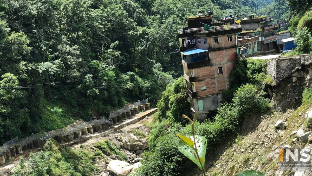
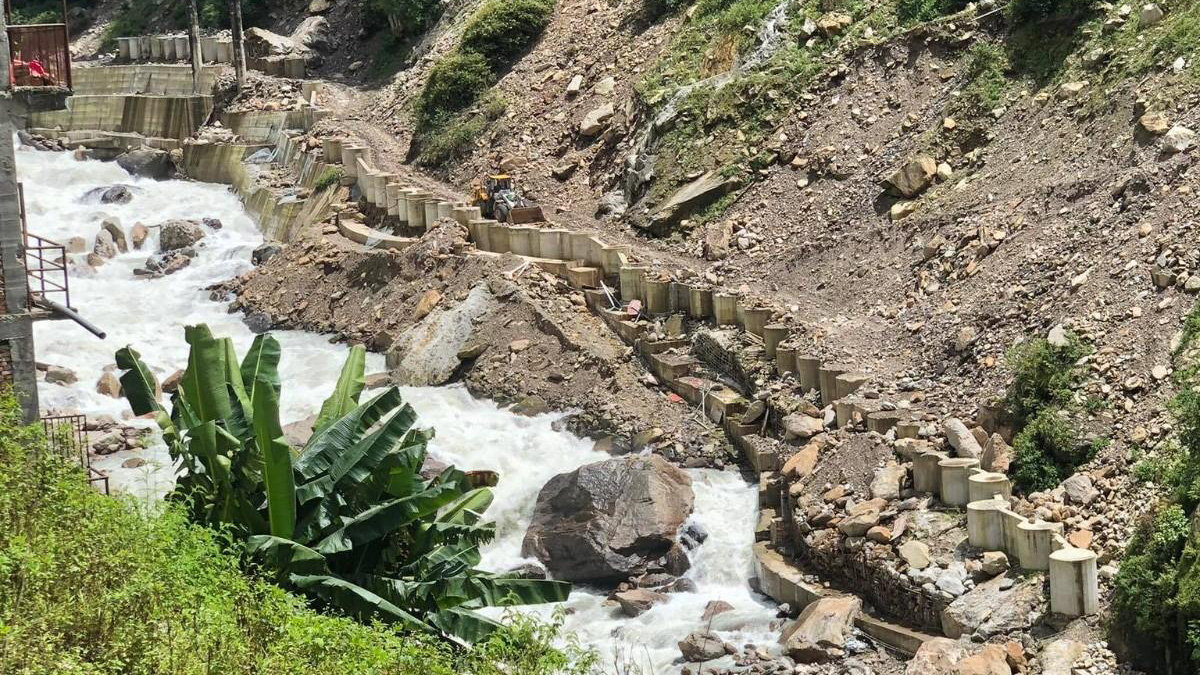
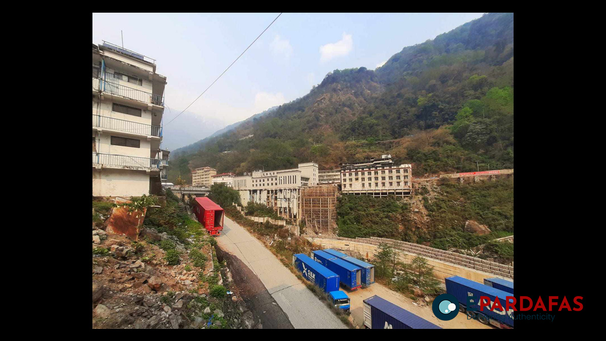
China’s accelerated development in Tibet, which directly influences the Nepal-China border, has generated adverse effects on Nepal. Regrettably, Nepali authorities have displayed limited interest in addressing these concerns. Meanwhile, China’s construction of a concrete structure aimed at altering the course of the Bhotekoshi River has not only impacted settlements along the border area but has also caused Nepal to lose substantial hectares of land.
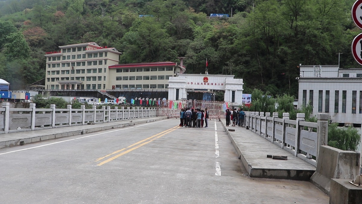
Currently, China is erecting a concrete structure resembling a two-lane road on riverbank land. This alteration in the river’s course has led to the displacement of a bus park that once stood in the Tatopani market. Site inspections have revealed the erosion of the former Tatopani customs area, parking lot, and even privately-owned residences due to the altered river flow.
Unilateral Actions Undermine Sovereignty
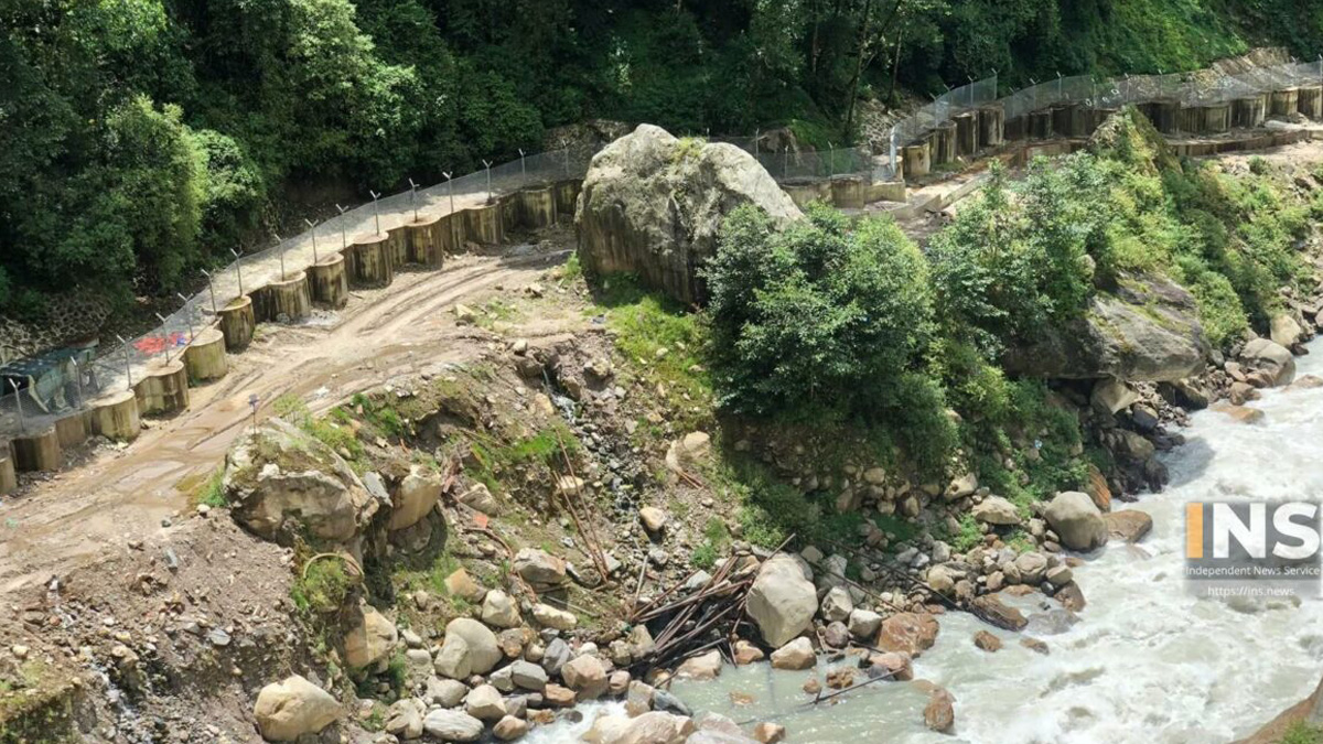
Notably, border expert Shrestha asserts that China’s actions in the Tatopani area are tantamount to encroachment on Nepal’s land. Through the deployment of concrete pillars and structural adjustments, China has manipulated the river’s trajectory, encroaching upon Nepali territory, particularly the Dasgaja area. Nepal has yet to formulate a response to China’s unilateral construction endeavors. Shrestha highlights that, until 2030 BS, the river had naturally flowed towards Nepal’s riverbank. However, China’s recent construction activities have transformed this region into a concrete corridor, a phenomenon not confined to Tatopani but also observed in Dolakha. Here, a large rock now displays the number “57,” replacing a pillar that once demarcated Nepal’s land.
Altered Rivers and Disputed Territories
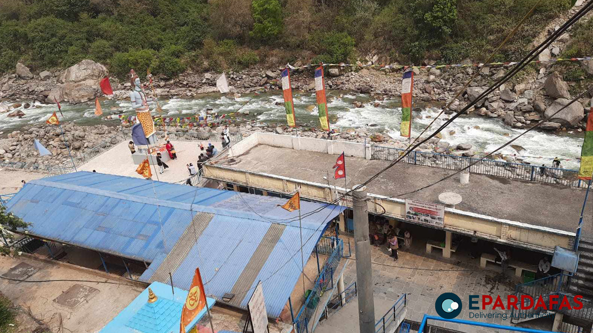
Local resident Nim Galjen Sherpa confirms China’s decade-long efforts to reshape the course of the Bhotekoshi River, causing it to flow onto land claimed by China. China’s construction of a two-lane road-like concrete structure on the riverbank has further substantiated these concerns.
In response, Pasang Nurpu Sherpa, Chairman of Bhotekoshi Rural Municipality, underscores that China’s manipulation of the riverbank led them to establish a one-way dam structure roughly 300 meters downstream from Miteri Bridge in Bhotekoshi Rural Municipality Ward No. 1 of Sindhupalchok.
Chairman Sherpa, after investigating the situation following local complaints, found that China’s unilateral construction efforts have triggered erosion and flooding, causing substantial damage to settlements along the Bhotekoshi area.
Moreover, China’s construction of a massive dam approximately one kilometer downstream from the Miteri Bridge area has seemingly resulted in the Bhotekoshi River altering the land’s topography, slicing into Nepal’s territory. Consequently, China’s actions have compelled the closing of border crossings, including the Tatopani border, raising concerns about the stranded festival goods destined for Nepal.
As China continues its construction projects and border-altering actions, Nepal finds itself grappling with territorial disputes, river course changes, and the broader implications on sovereignty and resources.
China’s Ongoing Actions and Border Disputes
Chairman Sherpa reported that earlier, there was news that China had cleared seven hectares of land along Sindhupalchok’s Kharane River and an additional four hectares across Bhotekoshi. In response, local authorities are demanding an immediate resolution of the border dispute by referencing the pre-Napi map from 2030 BS and assessing the Bhotekoshi River’s condition during that period.
This demand arises from the aftermath of the devastating earthquake in 2072 BS, which resulted in significant physical and human losses in Nepal. The collapse of the Miteri Bridge and subsequent border closures compelled residents of the border region to flee due to continuous tremors. Consequently, the presence of Nepali officials in the border area remained minimal for an extended period. Subsequently, floods and landslides wreaked havoc in the Bhotekoshi region. During this period, Chinese authorities closed the border and initiated the construction of a concrete structure along the Bhotekoshi shore without coordination with Nepal.
Altered Landscapes and Closed Borders
China’s construction of a massive dam approximately one kilometer downstream from the Miteri Bridge area has resulted in notable shifts in the Bhote Koshi River’s course, causing it to encroach on Nepal’s land.
Following this, China has consistently closed the border crossing as local residents raised concerns about these construction projects. Presently, China has unilaterally closed the Tatopani border, leaving festival goods destined for Nepal stranded.
Transformed Landscapes and Border Dynamics
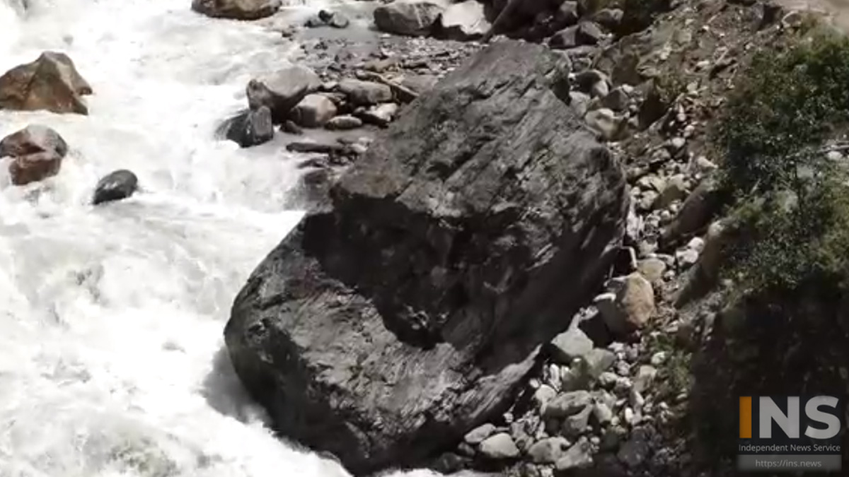
Comparing images taken after the inauguration of the Araniko highway in 2030 BS with the current state of the border region reveals that the Bhote Koshi River’s flow has completely entered Nepal.
The black rock, previously on Nepal’s side in the 2030 BS photo, has shifted towards China. This river’s altered course has led to erosion of the surrounding land, driven by the changing stream dynamics. Structures that withstood earthquakes and floods are now rapidly deteriorating due to Chinese encroachments. Locals assert that the expansion of road facilities in the Tibet-administered region by China is causing rivers and streams to enter Nepal’s borders due to the road network’s impact.
Response to China’s Actions
Concerning Nepal’s territory that abuts Tibet, both armed police and public law enforcement stationed to safeguard the Tatopani border have alerted higher authorities about infrastructure developments on the other side.
Nirajan Shrestha, Assistant Chief District Officer and Information Officer of Sindhupalchok, conveyed that no agency has provided written or oral information regarding China’s encroachments and construction of concrete structures in the Bhotekoshi Rural Municipality area.
Chief District Officer Ramesh Neupane expressed his commitment to collaborate with Bhotekoshi Rural Municipality and Prasari administration, ensuring prompt reporting to higher authorities. “We haven’t received any such information yet,” stated Chief District Officer Neupane.
Chief District Officer Neupane promptly mobilized the police to monitor the situation on-site, gaining an accurate understanding of the situation, and subsequently sent a letter. As bilateral discussions with Chinese authorities on reopening the Tatopani border crossing reach a positive resolution within the next day or two, Chief District Officer Neupane has pledged to visit the Tatopani area for inspection.


Comments